REDWOOD COUNTY
Reinvest in Minnesota / Conservation Reserve Enhancement Program Easement Evaluation and Outreach
Conservation easements are the primary tool to restore areas for various ecological benefits and protect high quality natural landscapes in the agricultural region of Minnesota. Easements are an alternative to fee title land acquisition, and still provide permanent protection, while remaining in private ownership. RIM (Reinvest In Minnesota) easements have been widely successful in providing wildlife habitat, reducing erosion, improving water quality, storing carbon, and increasing biodiversity across the landscape. The benefits are both immediate and long-term. In addition to the ecosystem benefits provided by easements, they serve as areas for hunting, wildlife viewing, recreation, and just plain enjoyment. Financial compensation offered through easement programs can be very important where marginal croplands are making farming unprofitable.
As one of the leaders in RIM/CREP easements in the State of Minnesota, the Redwood SWCD sought assistance from GRG to gather information about the condition of the easements within the county. The results aim to help develop strategies for landowners to help increase the value for wildlife, provide the needed ecosystem benefits, and potentially apply for long-term easement management funding. This information can also be used by conservation professionals when designing restoration activities.

Evaluating the vegetation on easements helps to assess the current condition of the site and determine needed management on existing easements and learn how to better design future easements. GRG ecologists collected vegetation data using a meander survey technique. Nearly 60 meanders were sampled on 21 RIM/CREP easements and 3 Prairie Bank Easements during August in 2021 – 2023. The number of meanders ranged from 1-6, depending on the easement size and habitat types present. The observed plant species and percent aerial coverage of each species were recorded.
This vegetation information was used to conduct various analyses. One compared the percentage of invasive species and native species to assign a rating of “high, medium or low” quality. Another used the Floristic Quality Assessment to calculate various aspects such as species richness, conservativism, non-native species cover, and the floristic quality index. Such vegetation surveys are important in conservation, as funding is limited, and this assists in determining priorities for enhancement or management.
Vegetation Surveys

It is crucial to have high diversity of floral resources on the landscape. Perhaps, more importantly, is an abundance in variation of blooms necessary to feed pollinators. Many trees, shrubs, and forbs have flowers with valuable pollen and nectar resources that can support pollinators. GRG ecologists evaluated the bloom times of 332 species of plants observed on the meander surveys. We looked at those plants with at least some benefit to pollinators, those with high value, and those essential for specialist bees. Highlighted here are those native plants considered to have high value to pollinators.
Bloom Time
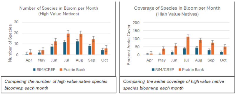
We looked at both the number of species on each meander as well as the percent cover of each species. This is a comparison between the RIM/CREP easement and the Prairie Bank easements. The objective was to see if the RIM/CREP easements are providing comparable benefit to pollinators. We found that, overall, RIM/CREP easements provided about 2/3 the number of high value species and 1/3 the aerial coverage of these plants as found on Prairie Bank easements. While we may never expect a RIM/CREP easement to mimic a remnant Prairie Bank site, we can strive to provide resources to better support native pollinators

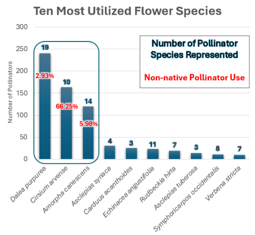
With training provided by the U of MN Bee Lab, GRG ecologists assessed 16 easements and recorded all observed pollinator morphospecies and associated plant species in July of 2022. The data analysis indicated a strong correlation between the plant's origin and the pollinator's origin. Native bees, moths, and butterflies were more attracted and observed on native flowers, while non-native pollinators exhibited a preference for non-native flowers. Of the 200 honeybees (from Afro-Eurasia) observed, 85% were found on those plants also originating from Eurasia.
The three plant species recorded with pollinators on them during the surveys were purple prairie clover (Dalea purpurea), leadplant (Amorpha canescens), and Canada thistle (Cirsium arvense). However, 66% of the Canada thistle use was by non-native pollinators.
Pollinator Surveys
Tree Canopy Cover
GRG ecologists analyzed 125 random easements (4,333 acres) for tree cover changes from 2010 to 2021 to evaluate the encroachment for large woody cover into adjacent prairie. Strategically planted areas, such as shelterbelts or fencerows, were excluded from the study.
Using GIS, the extent of woody encroachment was quantified by estimating canopy cover, using LiDAR-derived Canopy Height Models (CHM). In this study, the CHM-based canopy cover was calculated as the percentage of pixels with a CHM value larger than the woody encroachment threshold (10ft) within an individual easement.
The overall tree cover acreage increased from about 366 acres in 2010 to roughly 863 acres in 2021, a 240% increase in just 11 years. The greatest increase occurred on rock outcrop easements. In contrast, wetland easements had the lowest average canopy cover of 2.4% in 2010 and 7.5% in 2021. Buffer and Wetland easements had the least increase in woody encroachment between 2010 and 2021, at 4.1% and 5.0% respectively. Prairie Bank easements went down in canopy cover from 0.3% to 0.2%. For the easements where on-site vegetation surveys were conducted (1,364 ac total), the tree cover was 3 times greater in 2021, going from 94 ac to 286 acres.
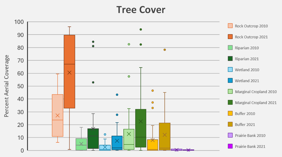
This data indicates that there are not enough resources being spent on tree control. This is likely a combination of money, ability, and perceived need. Many people are either not aware of the negative impacts of trees on these sites or did not have the ability or funding to do the work.
Key Conclusions and Next Steps

Volunteer Work and Landowner Outreach

To keep these private lands healthy and sustainable, it is essential that landowners be provided opportunities to learn the value and threats to these landscapes, and techniques to enhance and/or manage.
Following Great River Greening’s core mission of public engagement and stewardship, a component of this project involved multiple outreach events. GRG created unique events mingling the opportunity for volunteers and landowners to participate in conservation activities, while simultaneously introducing various management practices to be used on their own properties. Activities ranged from cedar removal, planting prairie seed in a red cedar removal site, and planting native prairie plugs on existing easements to increase diversity and provide better pollinator habitat. This area of the state does not have many opportunities for people to learn about natural resource management techniques and timing for use on conservation land.
Minnesota grassland ecosystems face many threats from forces including climate change, non-native species advancements, deficits in resources for native pollinators, and tree encroachment. Only 2% of southwest Minnesota is in public ownership, thus conservation easements on private lands are crucial to help restore and protect wildlife and pollinator habitat, create ecological corridors across the landscape, improve water quality, and protect soils.
This data is just the tip of the iceberg. Both proper easement development and stewardship is a vital next step. Providing more opportunities for landowners and the general public to understand and manage these ecosystems helps form a larger group of people with both the knowledge and aspirations to create suitable and sustainable habitat. Coupled with knowledge, new funding mechanisms for managing these resources are essential to the future success of the easement program. Increased funding would also provide additional opportunities for private businesses to build and expand to aid in managing these systems, particularly in southwest Minnesota. Awareness leads to interest, interest leads to enthusiasm, and enthusiasm leads to the desire to change and progress. When we know the world around us, it creates the desire to protect and sustain.
Partners
Minnesota Department of Natural Resources
Soil & Water Conservation District
Minnesota Board Water & Soil Resources
University of Minnesota Bee Lab
Many gracious landowners in Redwood County
View the full report:
Funding Provided By:
Minnesota Environmental and Natural Resources Trust Fund (as recommended by the Legislative and Citizens Commission on Minnesota Resources)
For More Technical Assistance Visit: